


介绍 Dynavix Navigation, Traffic Information & Cameras
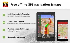
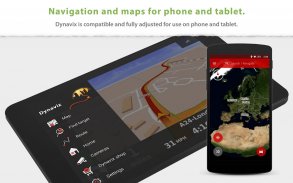
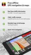
+ Free offline GPS navigation for Android.
+ Free lifetime updates of map data several times a year. Maps are stored inside the device, and therefore available wherever you are.
+ Intelligent route guidance using accurate traffic information and traffic cameras, in real-time.
______________________________________
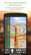
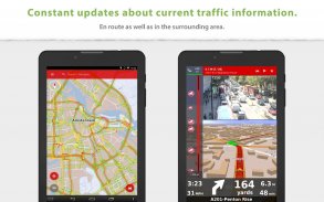
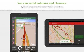
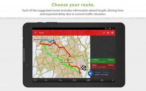
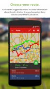
Using real-time traffic information to find the fastest route: Dynavix uses traffic data received on the basis of anonymous collection of data on the movement of other vehicles. With this feature, you can avoid e.g. impassable stretches in the morning or afternoon rush hour. The function of real-time traffic information covers 87% of the EU population.
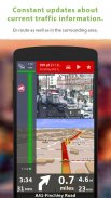
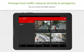
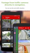
Snapshots from online traffic cameras near the planned route: Only Dynavix allows you to view data from traffic cameras located around the calculated route. In addition, Dynavix allows you to create custom lists of cameras, viewing data from cameras in the map, and other features. Dynavix currently supports access to over 7,500 traffic cameras across Europe.
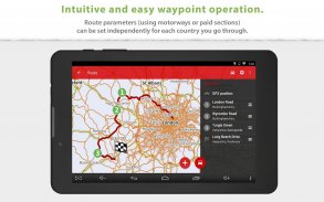
Advanced route planning using waypoints: The new Dynavix also significantly improves route planning with the use of waypoints. The planning is now very clear and adapted for use on mobile phones and tablets.
High-quality accurate maps: New Dynavix uses OpenStreetMap data. We believe the strength of the international community and current practice shows that OpenStreetMap are very detailed and often better than the maps from other providers.
The main functions of Dynavix:
• Turn-by-turn offline voice navigation using real-time traffic information (e.g. traffic jams or road closures) to find the fastest route (data provider INRIX)
• Views from online traffic cameras near the planned route
• Lifetime free map updates several times a year
• Advanced route planning using waypoints with the possibility of avoiding toll roads in certain countries or along the entire route
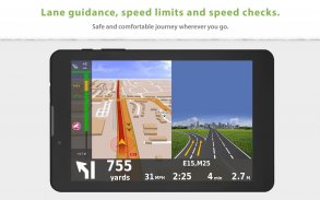
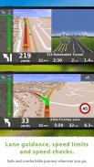
• Lane assistant and highway labels
• Full-text address search
• Alternative routes
• Support for voice commands via Bluetooth handsfree (Media mode or Phone call)
• Journey stats with possible export to *.csv
• Large database of points of interest
• 2D / 3D map view
• Speed check notification (with the possibility of importing community database radars)
• Speed limit warning
• Pedestrian navigation
• Wide range of view options personalization
Maps (stored in device memory):
Albania, Andorra, Belarus, Bosnia-Herzegovina, Bulgaria, Croatia, Czech Republic, Austria, Belgium, Denmark, Estonia, Finland, France, Germany, Gibraltar, Greece, Hungary, Italy, Ireland, Latvia, Liechtenstein, Lithuania, Luxembourg, Malta, Macedonia, Montenegro, Monaco, Netherlands, Norway, Slovakia, Slovenia, Spain, Poland Portugal, Romania, San Marino, Serbia, Sweden, Switzerland, Turkey, United Kingdom, Vatican City
Traffic information is available in the following countries:
Andorra, Austria, Belgium, Czech Republic, Denmark, Finland, France, Germany, Ireland, Italy, Liechtenstein, Luxembourg, Netherlands, Norway, Poland, Portugal, Slovakia, Spain, Sweden, Switzerland, United Kingdom
______________________________________
For more information visit our website www.dynavix.com
If you like Dynavix navigation, we encourage you to write at least a short review.
Notes:
• Navigation can dramatically decrease battery life even running in the background. Make sure you keep the phone connected to the charger when using navigation.
• The real-time traffic information function requires an Internet connection.
+适用于Android的免费离线GPS导航。
+一年多次免费终身更新地图数据。地图存储在设备内部,因此无论您身在何处,都可以使用。
+实时使用准确的交通信息和交通摄像头的智能路线指导。
______________________________________
使用实时交通信息,以找到最快的路线:的Dynavix使用数据的收集匿名对其他车辆的运动的基础上接收的流量数据。使用此功能,您可以避免例如在早上或下午高峰时段无法通行。实时交通信息的功能覆盖了87%的欧盟人口
计划路线附近的在线交通摄像头的快照:只有Dynavix允许您查看计算路线周围的摄像头流量数据。此外,Dynavix允许您创建自定义摄像机列表,查看地图中摄像机的数据以及其他功能。 Dynavix目前支持访问欧洲的7,500多台摄像机
使用航点的高级路线规划:新的Dynavix还通过使用航点改善道路规划。现在规划非常清晰,适用于手机和平板电脑
高质量的精确地图:新的Dynavix使用OpenStreetMap数据。我们相信国际社会的力量和当前的实践表明,OpenStreetMap非常详细,而且往往比其他提供商的地图更好。
Dynavix的主要功能:
•使用实时交通信息(例如交通拥堵或道路封闭)进行逐向离线语音导航,以找到最快的路线(数据提供商INRIX)
•在计划路线附近的在线交通摄像头的视图
•终身免费地图一年更新几次
•使用航点的高级航线规划,可以避免某些国家或整个航线的收费公路
•车道助手和公路标签
•全文地址搜索
•替代路线
•通过蓝牙免提支持语音命令(媒体模式或电话)
•可能导出到* .csv的旅程统计数据
•大型兴趣点数据库
•2D / 3D地图视图
•速度检查通知(可以导入社区数据库雷达)
•限速警告
•行人导航
•广泛的视图选项个性化
地图(存储在设备存储器中):
阿尔巴尼亚,安道尔,白俄罗斯,波黑,保加利亚,克罗地亚,捷克,奥地利,比利时,丹麦,爱沙尼亚,芬兰,法国,德国,直布罗陀,希腊,匈牙利,意大利,爱尔兰,拉脱维亚,列支敦士登,立陶宛,卢森堡,马耳他,马其顿,黑山,摩纳哥,荷兰,挪威,斯洛伐克,斯洛文尼亚,西班牙,波兰,葡萄牙,罗马尼亚,圣马力诺,塞尔维亚,瑞典,瑞士,土耳其,英国,梵蒂冈结果
以下国家/地区提供交通信息:
安道尔,奥地利,比利时,捷克共和国,丹麦,芬兰,法国,德国,爱尔兰,意大利,列支敦士登,卢森堡,荷兰,挪威,波兰,葡萄牙,斯洛伐克,西班牙,瑞典,瑞士,英国
______________________________________
欲了解更多信息,请访问我们的网站www.dynavix.com
如果你喜欢Dynavix导航,我们鼓励你至少写一篇简短的评论
注意:
•即使在后台运行,导航也可以大大缩短电池寿命。使用导航时,请确保将手机与充电器连接。
•实时交通信息功能需要Internet连接。
Dynavix Navigation, Traffic Information & Cameras - 版本6.6.25
(09-02-2024)Dynavix Navigation, Traffic Information & Cameras - APK信息
APK版本: 6.6.25程序包: com.dynavix.navigation同类应用
您可能还会喜欢……


